A Different Safari Experience

Clicking my fingers to get everyone’s attention, I cupped my hand to my ear and pointed in front of us. My finger went to my lips. 

“Can you hear the ox-peckers?” I whispered.

I looked at the group I was with, reading their faces for acknowledgement. Everyone huddled in. 

“That’s important, you need to pay attention?” 

“Ox-peckers could mean one of many things, right? It could be impala, giraffe or it could be something more serious. Maybe buffalo.” 

We paused to listen. An impala snorted. Our tension dissipated. 

Cradling my rifle in my elbow- I asked:

“Where’s the wind coming from? Who’s got the ash bag?” 

We all watched the wind blow a dusting of ash. We were on a game path leading to the river. By now we’d spent time differentiating lion and hyena spoor, found fairly fresh elephant tracks, and had an idea of the direction and speed the elephants had been moving in some thick brush. We’d established that it was too dangerous to try to follow the elephants into the thick bush by the river, but if we could get to the riverbank we might see them coming down to drink. We needed to be quiet, keep our eyes and ears open, and pay attention to the wind. 

“Pay attention to our safe ground. Let’s continue.” 

An elephant rumbled. 

“It’s o.k., that’s a content elephant sound. The wind is good, we’re being quiet, we’re good, but let’s get into position”.

The wind had was steady, and I knew once we got to the edge of the river, we would have big fallen trees as well as the bank to keep concealed and safe. We were already walking slowly, everyone on high alert. We crept around the branches of a fallen Acacia, a small group of elephant bulls stood in the sand, oblivious to our presence. I looked over my shoulder to make sure that everyone was there and then gestured for everyone to move forward and sit. We were close enough that a mistake would definitely spook the beautiful bull. Close enough that I could feel everyone holding their breath.

It was a typical training walk, similar to the ones that I conduct for various companies in Tanzania. But this one was slightly different. It wasn’t guides employed by any one company who were being trained, but a mix of interested individuals from various backgrounds. Sitting around the fire in June, Moli & Noelle from Kichaka and I had decided to run a course based on walking safaris, complete with rifle safety and handling. Covid had robbed us of our tourist seasons and all we wanted to do was be in the bush. We could offer a course that wouldn’t be limited to guides. Tanzania is such a biodiverse rich country and its National Parks are fairly easily accessible, yet high-quality guided experiences are generally inaccessible, not to mention a general lack of nature-based learning opportunities. For some independent guides, opportunities to practice skills and refresh were far and few between, not to mention opportunities for anyone wanting to learn guiding skills.  

Moli and a group of participants (two guides from northern Tanzania) watching a herd of elephants drinking in the river. Photo credit @ Hannah Strand

The diversity of backgrounds and interest meant that Moli and I needed to adapt our training. For some, skill proficiency was less important than the all-encompassing wilderness experience. For others, mastering the skills was necessary for their careers. Mornings became intense training sessions that lasted until lunch, then afternoons were spent at a different pace; doing yoga in the sand, game drives ending with sundowners, or fly-fishing in the river. Pretty soon, the murmurings around the campfire in the evening were revolving around how being there was so therapeutic. The big caliber rifles were intimidating, but everyone was succeeding at their own pace, overcoming their own fears and challenges. I had never expected shooting to be so transformative. 


Sunsets in the wilderness. Photo credit @ Hannah Strand


Over the second week of the course, our goal wasn’t explicitly to push people out of their comfort zones, but for the bush to become more familiar. If you want to get close to wildlife, if you want to get great photos of animals, if you want to observe cat behaviour, then you need to be in a vehicle. Wildlife will let you drive right up to it in a car, but walking is a different story. As soon as you venture out as the bipedal, apex predator, wildlife behaviour changes. Like us, animals have a fight or flight instinct and keeping safe on a walk means avoiding those situations. It means heightening your senses and gaining a deeper understanding of what is going on around you. Something as simple as being aware of where the wind is coming from becomes significant. 


Crossing one of the Ruaha's tributaries. Photo credit @ Hannah Strand.

As the course drew to an end, it was apparent that it had been a success. We had touched a hunger for a glimpse into the deeper workings of wildlife behaviour and ecology, the opportunity to spend an extended period of time in one place, and learning skills that would further open up an appreciation of the natural world. 

Hannah Strand leading a restorative yoga session on a sandbank.


(At the end of October I successfully organized a similar course in Tarangire. We focused on the naturalist and interpretive side of guiding- birding, tracking, and botany. A couple captioned images of that course here and here. If this experience interests you, we are running an Serengeti special in February.  E-mail me for the itinerary and details.)


A Private Guided Safari in Covid Times

Alone at the picnic site in Ngorongoro Crater. 

As the uncertainty around travel had forced many people to cancel or postpone their safaris, I had nearly rubbed everything off of my safari calendar. “If anyone is going to pull it off, it’s going to be you” said Moli as we sat by a campfire staring at the Milky Way. I kept my fingers crossed. The logistics were getting more and more complicated as the once reliable local airlines began shutting down their operations. We were the only booking on the charts for some of the remote camps, and international flight cancellations and policy changes were making us anxious. Everything needed a plan B and a plan C. Not only were we climbing Kilimanjaro, but we were flying across Tanzania to visit the Mahale Mountains to see chimps. What about covid and the chimps? Was I being irresponsible? With a solid plan in place and the support of every player in the itinerary, I held my breath. The lengthy discussions on mask protocols, hygiene, dining, what-ifs repeated themselves.

One of the incredible views of Kilimanjaro on the Lemosho route. 

The last time I climbed Kilimanjaro was in 2000, my senior year of high school. I loved outdoor pursuits and teachers often took my name off the sign-up lists for mountain trips to give others a chance. Yet, as a guide, I had not been up the iconic mountain. One route I had never done on Kilimanjaro was the west approach across the Shira plateau. Known as the Lemosho route, this is the longer approach. At 8 or 9 days, it offers the highest success rates because it gives you the most acclimatization time. To call it the most scenic would do injustice to the beauty of the whole mountain, but it does offer some magnificent angles. Having a high-success rate doesn’t make it an easier route but under the brilliant leadership of Summits Africa guide we all summited. 

The snow capped peak and dwindling glaciers from Uhuru peak. 

Our next destination was northern Serengeti where we hoped to find some wildebeest but also experience the incredible resident wildlife. Northern Serengeti is fast becoming known for exceptional leopard viewing and we were rewarded by a leopardess with two adult cubs who allowed us to follow her for a few hours one morning. Watch a snippet here. In addition to some of the Serengeti’s best wildlife viewing, it is just a beautiful area and I love it any time of year. I chose to stay at Nomad’s Lamai camp. Nestled into a rocky outcrop known as Wogakuria it looks out on the rolling hills towards the Mara river and onto the Lamai plains on the north. With so few people in camp (us and a film crew), the staff were eager to not only show off their masks and covid protocols but also set up an amazing bush lunch for us. 


After a full morning of game viewing we pulled up for lunch in this beautiful setting. A massive herd of wildebeest made its way down towards the river, scattered by a herd of thirty elephant making their way from the river. 

From Serengeti we flew across to the shores of Lake Tanganyika. Lake Tanganyika is a long, deep rift valley lake. In fact, it is the longest lake in the world, and second to only Lake Baikal in depth. It contains almost one sixth of the Earth’s fresh water, but we hadn’t come for the beach. The forests along its shores are home to Tanzania’s population of chimpanzees and Nomad was opening Greystoke for us. The guides had difficulty containing their excitement too. Greystoke has an incredible team of guides who were all part of the chimpanzee research team. They know the chimpanzee the way we know the people in our communities, and they hadn’t seen them in months. In the few months preceding the Covid closing, Primus, the alpha male was being challenged with by a serious rivalry and they were keen to see who had taken over.


Humans and chimps are so close genetically that we were obviously concerned that we were taking a risk,  however, chimp viewing rules in Mahale had for nearly the last decade made people wear masks. Since the masks had been introduced, no chimp (that we know of) had gotten a cold from a human so we were pretty confident that if we took extra precautions with hand washing and hand sanitizing we didn't pose a risk. Most importantly we would also not push the distance recommendations and comply with the guides. As a side note- "social distancing" from chimps is 10 meters (30ft) not 2m, which seems to be the current CDC recommendation. 


Michio, one of the adult males who was a potential contender for alpha male. The guides are happy that it appears that Teddy has taken the reigns. Teddy is a gentle male, and they expect great chimp viewing while he is at the top. 

Rounding off the itinerary we departed Mahale for Ruaha National Park to wrap things up with a walking safari and ultimately a night of fly camping. I have spent enough time in Ruaha that it has not only had a formative influence on my guiding, but has also influenced my perceptions of what a great wilderness is. A sentence with Ruaha in it rarely doesn’t include walking safaris and so we set off for a remote corner that Moli & Noelle have carved out an exclusive operation. Perched atop a bluff overlooking the Ruaha River is the main camp and we arrived in time to settle in and grab a drink by the campfire to watch the sun go down. 


A typical, dry season, Ruaha sunset.

A Journey Through Ethiopia: Part 6 Chebera Churchura

Our last stop on this journey through Ethiopia was a small National Park called Chebera Churchura. High up in another mountainous region of Ethiopia, this National park barely features on any map. Like many of the Ethiopian National Parks, preservation of the natural habitats has come second to development, and a massive tarmac road was being cut through the forests like an ugly amazonian logging road. We’d come in search of one of the last strongholds of elephant in Ethiopia- and the enchanted forest in which they roam. We had arrived a little early in the season and the vegetation was still incredibly thick. Walking was a high-alert, high-adrenaline activity as we wandered the forests catching glimpses of Bushpigs. 

Camped in an enchanted forest.
We were very fortunate to catch some good views of elephants, occasionally clambering into trees to see above the ground cover. The real highlight of this park came the last night, when we took a walk that took us past some hot-springs that were frequented by people and their cattle. As we returned, the local rangers suggested that because no one was around that we sit on the rocks above the springs and see what might enfold. A troop of baboons came down and began their politics, but oblivious to our presence they created an atmosphere of trust, and minutes later, a Giant forest hog wandered into the clearing. A sow with hog-lets joined him. As we sat, filming and photographing, more sows came out and as the darkness began to threaten, we counted a total of 21 Giant Forest Hogs.


The Giant Forest Hog and hoglets are a forest species.

A Journey Through Ethiopia: Part 5 People of The Omo Valley

Camped out on the edge of the Omo River, Kara country, Ethiopia.
Anyone who has turned the pages of the book African Ceremonies will be familiar with the images of people with painted bodies, people with elaborate braided and ochre-coloured hair, people wearing massive lip-plates, and photos of boys running over the backs of bulls. All of these images come from the famous Omo valley in southern Ethiopia, where the livelihoods of these tribes is now threatened by hydro dams and massive commercial sugar cane farm developments and changing political administrative structures.

We ventured into the Omo valley, our schedule very flexible, but with the hope of visiting the Mursi, Hamar, Bana, & Kara. The following images and captions represent the experience more than any narrative.

A Kara man, with his rusty rifle. 

Drinking coffee husk tea with the Bana.
A Mursi girl dons her adornment for a photo. 


In addition to lip plugs, the Mursi also stretch out their earlobes. 

A recently formed clay lip-plate dries in the afternoon sun.
The Hamar jumping of the bulls ceremony which begins with women being whipped and dancing.


A Journey Through Ethiopia: Part 4 The Bale Mountains

After some long days in the car and the intense heat of the Danakil, the cool of the Bale Mountains came as a relief. We arrived at Bale Mountain Lodge in the dark and woke the next morning to the mist rising from the forest to reveal a beautiful glade, the Harenna forest as the dark backdrop. A pair of Abyssinian slatey flycatchers perched on a branch, occasionally swooping for an insects while we sipped our coffee. A fantastic White-cheeked turaco swooped 
into the tree above the lodge.
An incredible view of the Harena forest in the Bale Mountains. Bale Mountain Lodge.
The Bale Mountains are a series of extinct volcanoes that form a plateau known as the Senneti. Rising from around 2,000m to over 4,400m above sea level. One the south side, they are covered in an enchanted forest known as the Harenna forest, home to shy lions and Giant Forest Hog. The north side is covered in beautiful Pencil cedar and Hygenia abyssinica, and graced by the beautiful Mountain Nyala, while the top of the plateau is covered in alpine grasslands, dotted with red hot pokers and giant lobelias, but more importantly, home to the last stronghold of the Ethiopian wolf.

It was the wolf that had brought us here, so we bundled up, grabbed a packed lunch and headed up to the plateau. As we drove up above the heather zone and onto the afro-alpine moorlands on this glaciated landscape, the presence of a prey base became very evident by the impressive number and diversity of large raptors. Augur buzzards, steppe eagles, tawny eagles, the occasional lesser-spotted eagle rode the updrafts searching for rodents. A pair of Verreaux eagles worked a cliff face in search of hyrax. 
The Simien wolf or Ethiopian wolf has adapted to eating rodents.
Finally, after driving across nearly half the plateau, we spotted our first wolves. Grabbing our binoculars, lenses, tripods we began the stalk. This became the routine of the day and by late lunchtime we’d seen nine wolves. Some very habituated had let us get within meters of them, others kept a distance of 50m. Satisfied we returned to the lodge.
  

The next day we pulled off the bumpy main road onto a small track that leads to one of the wolf research stations. Our landrover was parked, the camp supplies spread out on the ground as the horse team began divvying up loads, rolling mattresses and tying the loads onto the horses. Three horses were saddled and ready to ride, so after figuring out what we needed we proceeded to mount and set off. Within 5 minutes we had seen our first wolf of the day. The sun was shining and we rode across the spectacular landscape, past giant lobelias and clumps of everlasting flowers. The views were intense and soon I realized I needed to be on the ground to capture any photos and videos of this incredible ride. Around lunchtime, we rode up through a pass and stopped to take in the panorama. High peaks rose up behind us, and before us a steep sided valley with a small lake. Not a soul in sight.
Glacial features in the Bale Mountains.
We continued, down through the valley, across another ridge, and then up through another valley. Pausing for a rest in one valley, we glassed a cliff face where a pair of golden eagles displayed, eventually landing next to their nest. That afternoon, we rode up over the final ridge and descended to our campsite. Tea was ready as we pulled in and we relaxed watching the horses graze in the flats below.
 
Great trails for riding the local horses or hiking.

Around every corner was another expansive view. 

Glacial valleys where Black Eagles soared.

That night was cold, and we woke to a small layer of ice on our tents. The clouds were low, hiding the magnificent peaks, but as the sun rose so did the cloud. We set off again. Today was mostly downhill and we followed a stream down through the valley finally coming out in the Web valley. This was one of the last strongholds for the Ethiopian wolf and we watched a pair forage while we ate our lunch. Another couple kilometers and we rode into camp. Again, tea was ready but we were also eager to photograph the wolves so we quickly set off on foot.

Ethiopian wolves live in small packs with an alpha male & female. During the day they forage individually, their physique specialized for hunting rodents. With big ears, pointed muzzles and sharp teeth, they pounce on their favourite prey, the endemic Giant Mole Rat as well as a host of other species. Their social interactions occur early in the morning, and late in the evening and involve a short greeting ritual. We hoped to witness this.
 
Expansive alpine landscapes.
It’s difficult to stalk in the open alpine grasslands, but we did our best using rocks and ridges, belly crawling over the tops and then scanning with binoculars. A couple times, the wolves spotted us and kept their distance, but finally we found a pair resting beside a clump of Everlastings. We could see another couple wolves in the distance, also resting. The wait began, our local guide was convinced that we’d see the greeting ceremony, but with the cold wind, and darkness quickly approaching we abandoned our post. As a Cape Eagle Owl flew from a rocky ridge, we watched as it silently and deliberately flew across the valley, discussing the patience and frustrations that wildlife photographers and film-makers go through getting the amazing BBC or National Geographic quality footage.

The next morning, while it was still very dark and cold, we scrambled out of our tents, and headed to where we’d left the pack. It was cold and we walked in silence. There was a light wind and fog that would make it difficult to spot them and we hoped that we wouldn’t spook them. As we came up over a ridge, our guide suddenly hurried us back. Lying right where we had been lying the evening before was the pair of wolves. Their orange and grey colors blending so perfectly with the lichen covered rocks. Quietly we took cover, set up tripods and zoom lenses and waited. 5 minutes, 10 minutes, 15 minutes, finally another wolf came up over the ridge. Another 5 minutes, 10 minutes, and then one stood up, walked over to another one, and the greeting began. Shaking with excitement, we were glad to have a tripod holding the camera. We let the video roll.

A Journey Through Ethiopia: Part 3 Inhospitable Habitats

An aerial view of Erta Ale.
Having climbed Nyiragongo in DRC, the opportunity to see another lava lake beckoned us into the harsh Afar region to climb another active volcano, Erta Ale, and to visit the inhospitable Dalol. This environment competes with Death Valley for hottest place on Earth and is at it’s deepest point 120m below the sea level. It is found at what geologists
term a triple junction, where 3 continental plates are pulling apart. When this happens, like in the depths of the ocean, chemicals and molten rock rush to the surface.

As we descended from the plateau into the valley, the vegetation changed.
Our first destination was Erta Ale. Dropping from the high-plateau in the Tigray, the temperatures slowly rose. Wheat-fields transitioned to scrub, cows and donkeys to goats and camels, and smiling farmers to suspicious rusty AK47 wielding camel keepers. Eventually we found ourselves crawling along in low range over a volcanic lava flow, a whisp of smoke rising from a distant hump. A few paths crisscrossed the sharp, jagged, black rocks and for were it for the occasional camel, or dry country lark the area seemed almost sterile. With this heat, we were relieved that we would be climbing in the dark. We arrived at the base camp, an unimpressive collection of grass and rock shelters, in time for a quick nap and light supper. Our guide negotiated with a camel owner to carry mattresses and water as other vehicles pulled up. Wanting to avoid walking in a crowd we left soon after dark, headlamps illuminating the rocky path as we slowly made our way towards the growing glow. That night we crossed the freshly hardened lava from an eruption last year to the edge of the smoking cauldron. The occasional wind change would engulf us in suffocating smoke, searing our eyes and lungs and sending us into coughing fits as we perched precariously on the edge, hoping for relief from the wind and a glimpse of the bubbling lava. As dawn approached we realized we would not see the actual lava, and began our descent racing the building heat. 

Standing on top of an old cone in the glow of the lava against a starry sky.
The race to avoid heat was going to prove to be futile. We climbed back into the vehicle and made the long way back up into the mountains and then back down along a beautiful winding road before emerging in a Mars like landscape of the northern Danakil depression. We crossed a stream and decided the camp vehicle should negotiate with the nearby village for a campsite while we continued. We stopped in a small village called Hamadilla, where an armed policeman joined us. A kilometer further and the tarmac ended abruptly and before us lay the great salt lake of Karum. We picked up a couple cold beers and drove out onto the lakebed to catch the stunning sunset.
The salt lake at sunset.


The next morning we were up at 5. The temperature had dropped to a reasonable warmth and we set off to catch sunrise at Dallol. Dallol, often mistaken for a volcano, is actually an upwelling of hot water and steam caused by a magma reservoir a couple kilometers below the surface. Rising through 1,000m of layer and layer of salt, the hot solutions mixed with primordial gases from deep within the Earth react pushing up this unassuming 60m high mountain, spewing and bubbling with so many chemical names that any scientific paper on the area looks like a random assortment of element and number combinations interspersed with random English words. Talk about wishing you’d paid a little more attention in chemistry class.
 
The incredible variety in chemical deposits, Dalol.
We stepped carefully between the salt pillars, navigated circular manifestations and acid pools, some with pH’s approaching 0.5. Kneeling down and looking for unique camera angles, the local guide would occasionally remind us, “that is really poisonous” or “don’t let that get in your eyes”. Our next stop was a series of a couple of ponds, where our guide explained that methane mixes with the water and makes it feel oily. Dead migratory birds lay on the edge where they had drunk the poisonous water. As the heat was building, we stepped back into the air-conditioned vehicle and sped across the salt flats. It was time to get back to the cool Ethiopian highlands.
A poisonous pond, Dalol. 

A Journey Through Ethiopia: Part 2 Community Treks & Abuna Yemata


With limited time, we pushed on. Cruising the winding new tar roads, delaying our arrival with yet more stops for “just one quick picture”. Abruptly we turned off the main road and onto a rural dirt track. A jovial lady walked up to the vehicle and climbed in.
 “My name is Berhan, I’m going to be your guide for the next few days, are you ready to walk in the dark?”
20 minutes later, as the sun began to drop in the sky sending incredible rays through the clouds, we began our trek. Like stepping into biblical times, our bags were loaded on a donkey and we made our way through golden wheat fields and through a valley. The sun set and we walked on passing farmhouses, a short cut between two fields. As the twilight began to fade, Berhan turned to us:
“We’re almost there, we just have to climb to the top of this plateau.”

The long drive and slight apprehension at walking somewhere you’d never been in the dark made the climb seem a little harder than it was, but as we came up over the lip of the plateau, sillouetted against the last light of sunset was Erar, a community guest house perched on a cliff.


As we arrived, clouds rolled in and an unusual drizzle threatened. Stumbling around with headlamps we found our rooms, grabbed warm clothes and then headed to the dining room. Dinner was being prepared and we sat in the dark, a small lantern lighting up the room. A couple beers and a bottle of wine were brought out from somewhere and we sat tired but content. Berhan explained to us that there is a series of community guest houses that are a day’s hike between. There are no roads so all supplies are brought in by donkey or carried. Cooks and helpers worked on a rotation so that many people would benefit from the tourists who come through. It felt good to be there.

The next morning we were up as dawn broke, cameras and tripods set up to capture more video footage, then we went in for our first real Ethiopian coffee ceremony. Coffee is served differently in different regions of Ethiopia, some make an infusion of coffee berry husks, others use the leaves. We would experience the Tigrayan ceremony.  

As we sat there, eager for our morning coffee, the host brought out some hot coals in a clay stove. She took a handful of green coffee and put it in a special coffee roasting pan, shaking the pan to keep the beans moving and roasting evenly. Soon the smoke and aroma of roasting coffee filled the room, ever stimulating the eagerness for a cup. The coffee was poured into a mortar and pestle and she ground it, occasionally testing its consistency. Soon it is ground enough and she poured the grounds into the clay coffee pot and added water, placing it back on the coals. Within a few minutes coffee spluttered from the spout of the pot and she added a little cold water, repeating this until finally she could pour us our first cup of coffee. Tradition has it that the process was not over, and the pot was refilled with water.  Every coffee ceremony must produce three rounds of coffee.  Adding to the ceremony, our host quickly grabbed a pan, poured some popcorn kernels into it and held it over the coals to produce the most complete batch of popcorn I’d ever seen.

Popcorn and a great smile!
Soon we were back on the trail, weaving again through the fields. Farmers chased geladas from the grain fields and dogs barked at as we passed homesteads. The walk took us along the edges of cliffs, down into valleys, past ancient churches and I couldn’t help but think that people are living in very much the way that people in the area have for the last two thousand years. The walk was just the right length and we arrived at the next guest house, Shimbrity, ready for some authentic Ethiopian injera and shiro. That afternoon, we took a walk along the edges of the cliffs soaking in the spectacular views.  

A shepherd herding his sheep. 
During our travel planning stage, we came across this short video, and decided our journey through Ethiopia would not be complete if we did not attempt to visit this church. Having not met one other tourist while on the community trek, we were a little apprehensive as we approached the base of the mountain. Long lines of people were snaking their way up, but our guide quickly explained that the next day was the day of the saint for this church and people had made a pilgrimage. A mass would be conducted in the church for the whole night. We began the hike making way for kids running up in flipflops, the elderly climbing to a sacred Olive tree a third of the way up. Soon after we were asked to remove our shoes, and the rock climbing began. My palms became sweaty and the urge to curl my toes as I faced the rock face. Everyone was helping everyone so we began the climb.

An elderly lady makes the pilgrimage.
“Put your left hand here, put your right foot there now, o.k., now reach here”. 
The hundreds of years of people climbing this perilous rock face had left hand and foot holds in all the right places, like an easy route on a rock-gym wall. Soon we were climbing on a path again. 
“Are you afraid of heights?” quipped the guide? “A bit late now”, we chuckled as we came up to the penultimate ledge. 
The view was spectacular, but with the drop off, I kept well clear. Our timing was perfect and the sun had gone behind some clouds giving us an incredible sky as a backdrop to this breathtaking view.
“O.k. careful now”, said our guide and we began the terrifying last section. A loose log leaned against the rock was the handhold as we scrambled across the natural rock bridge and up the last bit to a 2 foot wide path that led around to the entrance. The priest watched us from a window.

The inside was dark, but our guide quickly lit some wax wiks and the elaborate paintings were revealed. These churches, hidden from view, carved out of the ancient sandstone rock high-up in these mountains were made somewhere during the 5th century. Hidden from marauding militias and crusades, these monolithic churches could not be burned down.
The last push.

A Journey Through Ethiopia: Part 1 Lalibela & The Simien Mountains


The journey to Ethiopia began as a discussion at the end of an incredible adventure through Madagascar of “where next”? With an extensive list of experiences accompanied by an impressive biodiversity list from Mountain Gorillas to Madame Berthe’s Mouse lemur, all of the cats of the savannahs, from tracking elephants on foot and flying over Lake Natron in an ultralight, to lying in the mud photographing flamingos, staring into Nyiragongo, and tiptoeing through the Tsingy photographing leaping lemurs, the most obvious big destination was Ethiopia. The rare and endangered Ethiopian wolf, grass eating Geladas, and the Walia ibex, became our target species and the challenge to experience Ethiopia in the same style as Tanzania, D.R.C, and Madagascar.

I am a very nature-oriented guide and place a lot of value in the wildlife experience and the value of the wilderness experience. A huge part of the adventures I put together is in the seeking, or the hunt as some would say. I emphasize being the first out, the last in at night, taking the road less travelled, going out-of-season to experience places without hordes of tourists. Ethiopia intimidated me a little with its churches, castles, 100 million people, and AK47 wielding tribes and getting beyond the beaten track even though we had four weeks was going to be a challenge.

Bet Giorgis, one of the impressive rock hewn churches of Lalibela.
Our journey began with a flight to Lalibela, the famous rock-hewn churches where we opted for a whirlwind tour.  Our whirlwind tour continued, on to Gondar where we explored the castles of this medieval Kingdom before stopping at our first wildlife destination, the Simien Mountains.

One the day of the saint, followers flock to the church. 
We sipped coffee as dawn began to break through the clouds, our tripods set up and time-lapses rolling as the sun slowly revealed the spectacular landscape. Grabbing a flask of coffee and packed breakfast we drove into the park. It was difficult to get far because over every ridge and around every corner a new vista would open up and the never ending urge to try to capture the incredible vistas. Our immediate goal was an area of the park known as Chenek, the best location to find the Walia ibex from where we would work our way back.

The magnificent male Walia Ibex of the Simien Mountains. 

Walia ibex perched on the cliffs.
We paused for a coffee and snack, binoculars scanning the mountainsides for the glimpse of this iconic species, finally catching sight of the recurved horns silhouetted against the sky at the top of one of the mountains. Grabbing cameras and lenses we began the scramble, soon realizing that at 4,200m (13,700ft) we were going to have to take it slow despite our excitement. Our huffing and puffing was rewarded as we came around a boulder, and right in front of us the most impressive male ibex lay sleeping.  We sat quietly in awe, catching our breath and playing with camera settings. Suddenly a movement off to the right and we realized that there were more. In total 8 mature ibex. Not a bad start to Ethiopian wildlife.

The next target species was the Gelada, a specialized terrestrial, grass eating primate, similar in size to a baboon. We’d already seen some on the drive, but closer to the park entrance was a group that was being researched and thus habituated to humans. We pulled up as the light softened and the Geladas began to make their way back to the cliffs, rapidly feeding on grasses and herbs all the time murmuring.
Geladas getting ready to retreat to the safety of the cliffs for the night. 

The next morning we found ourselves on the same verandah, coffee in hand, tripods set up and time-lapses running. After a quick breakfast we loaded the vehicle and left. A long and tight-winding road built by the colonial Italians took us to the base of the Simien Mountains, across the Tacazze river and north to Axum. We stopped for lunch and then ventured to the Stelle park. The oldest Stelle in the park date to 2 AD, glorified tombstones build by kings, and of course each king had to commission a bigger and better stelle. In the middle of the park lies a broken stelle, one that no one is sure ever stood, and if it did why or how it fell.


The Gorilla Story Part 1. Some Insight into Mountain Gorillas.


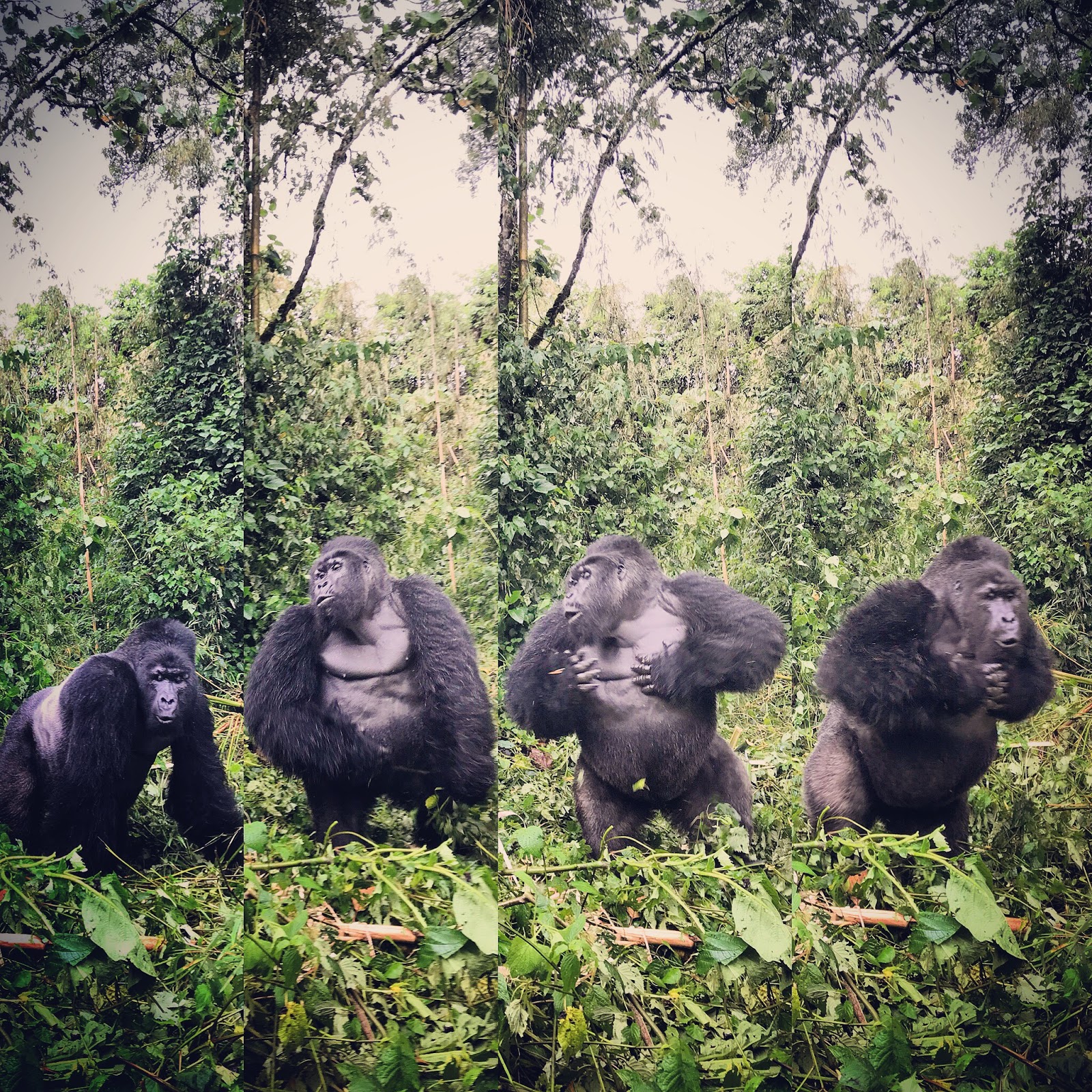
Kasole of the Munyaga group beats his chest for us! Watch a video here. Who is Kasole? Find out here. 
 Having returned from guiding my nineteenth gorilla trek in fourteen months, I thought I’d share some of the insight that I have gained so that if you are considering a trip to see mountain gorillas you have more than the standard info pack you might receive from standard operators.

I personally prefer trekking in Virunga National Park in the Democratic Republic of Congo. The experience is slightly less regimented, sometimes disorganized, but is undoubtedly more intimate. The history of the gorilla groups in this article therefore applies to the groups in DRC, however, the Mountain gorillas are essentially the same wherever you are in the Virunga Massif. 

Below are some frequently asked questions (see my next post for some history into the make up of the six of the gorilla groups you’ll most likely visit in DRC):

How many species of gorillas are there?
There are 2 species of gorilla- the eastern gorilla (Gorilla beringei) and the western gorilla (Gorilla gorilla). The former is found in Virunga and split into two subspecies- the Mountain Gorilla of which half live in Virunga National Park, and the Eastern Lowland Gorilla (Gorilla beringei graueri) found in northern parts of the park and in Kahuzi-Biega National Park south of Lake Kivu.

How many mountain gorillas are left in the wild?
This question is a bit of a misnomer because mountain gorillas don’t survive outside of the wild. In fact, the only place where they survive in captivity is at the orphanage at Mikeno Lodge. While the results of the 2016 census have not yet been released, the estimates are that there are now over 1,000 mountain gorillas in the wild, between Bwindi National Park in Uganda, and the Virunga Massif. Stay tuned for up-to date information.

How big is the area that the mountain gorillas live in?
The amount of land that mountain gorillas have in the Virunga massif is on 447km2. You can clearly see the pressure of humans on the land when you look at a satellite image of what is left of the forest. An initiative by the Virunga is buying land adjacent to the park to replant bamboo and expand the area available to the mountain gorillas.
The forest (East) of the N2 in DRC is home of the Mountain gorillas. As you can see, the area of land in DRC is much greater than that in Rwanda.
 What do mountain gorillas eat?
Mountain gorillas are vegetarian but occasionally will raid a nest of safari ants (Dorylus sp). and sometimes eat mushrooms. They select from over 60 different species of plants but their favourite is bamboo which may make up to 90% of their diet during bamboo shoot season. The rest of the time, over 75% of their diet consists of 3 species: (Galium ruwenzoriense, Peucedanum linderi, and Cardus nyassus). A big silverback can eat up to 30kg per day. 

The blue sign represents the new park boundary for bamboo project. Expanding the habitat for Mountain Gorillas.  The forest in the distance is the current park boundary and limit of Mountain Gorilla habitat.
Are gorillas territorial?
No. Mountain gorilla groups live in overlapping home ranges that vary in size from 3 to 34 km2 depending on group size and food availability. They tend to move less than 1 km per day, resting and feeding for about the same amount of time. Occasionally when they encounter other groups or danger they will travel further, but not usually more than 3 km in a day.

What do you mean by a silverback?
The term silverback refers to a full-grown male gorilla. Male gorillas mature somewhere between 9 and 10 years old. At this time they are already much bigger than the females and the hair on their backs begins to turn white or silver. Somewhere between 12 and 15 years old, they reach their full size and can now begin to compete for females. They are now considered a silverback.
Humba's son poses for the camera. Who is Humba? Read this post.
While the specific make up of each gorilla group is different, gorilla groups are led by a dominant silverback. It isn’t completely straight forward and there’s a lot that is going on that we can’t see, but it seems that females choose who to follow. Remember, these are highly intelligent primates. Dominant silverbacks will usually tolerate other silverbacks in their group either because they are their sons, but occasionally they will also tolerate non-related silverbacks in the group- it is after all advantageous to have a strong coalition when they do encounter other gorilla groups to help guard the females from being abducted or convinced to join the other group. Silverbacks are very protective of their groups and will display and act violently towards perceived threats including lone males and other gorilla groups.

How do you tell the difference between a male and female gorilla?
It is actually quite difficult to tell the difference between a young male and young female gorilla unless you see the penis. Gorillas have internal testicles so you can’t go by that visual cue either. However, adult gorillas exhibit sexual dimorphism (the fancy word for males & females looking different)- mainly in size and the obvious “silver-back” of a fully mature male. An adult male gorilla can weigh more than 155 kg which is almost twice what a big female weighs (80kg). If you could look at their skulls, you’d also see that the males have bigger skulls with a very pronounced sagittal crest. This is the attachment for the chewing muscles. They also have fairly large canines.

What is a gorilla’s life like?
Babies are born after a 255-day gestation period. They weigh about 2kg at birth. Twins are sometimes born, but it is very stressful for the mother and they rarely survive. 18% of infants die in the first six months- and the mortality is higher in the wet season because of respiratory diseases. Another 16% will not make it to 3 years, but after that they have a good chance of surviving to adulthood (8 years).

Females mature at 7-9yrs and usually have their first baby at 10. From then on they have babies about every 4 years for the next 20 years. When males mature, they will often leave the group they were born into and join small groups of males or become solitary hoping to start their own families. Mature females also leave the groups they were born into and either join other groups or solitary males to form new groups.

What is a typical day on a gorilla trek?
Usually somewhere between 6 a.m. and 7 a.m. small bands of trackers and rangers head out to find the gorilla groups. They do this regardless of whether any tourist is going to visit for monitoring purposes. Because the gorillas tend not to move that far, the trackers head out to where they saw them last and begin tracking from there. 

Meanwhile, back at the ranger’s station, you are waiting for the registration process to begin. You’ll have your permit in hand and you fill in your details including passport number into a book and then sit down to wait for a briefing. It is fairly simple in Virunga, because there are fewer groups, and fewer people visiting, so you all sit in one room and the head ranger explains gives a short explanation of the gorilla groups and which ones you will visit. When you are ready to go, the rangers distribute facial masks and ask you to sanitize your hands.  At this point if you would like a porter to help you with your bag (and hold your hand on the slippery slopes) they are waiting outside ($15 fee per porter paid directly to the porter). You can also buy a walking stick for $10.  Once this is done you head off on the walk. The rangers have a fairly good idea of how long it will take to get to each gorilla group so you head off through the fields adjacent to the park to one of the numerous paths that enter the forest. When you enter the beautiful forest you head along a network of paths to where the trackers have found the gorilla group that you will visit. The trek can be anywhere from 20 minutes to 3 hours. You leave your bags and take only your cameras. I recommend carrying an extra camera battery and memory card in your pocket because you will likely take a lot of photos and video. You will don your mask and slowly approach the mountain gorillas. The rangers will vocalize to the gorillas to let them know that everything is ok and you will begin your 1 hour with the gorillas. This is non-negotiable, but if you want to spend more than 1 hour per day with gorillas, and have a relatively good fitness level- contact me. In my experience, the rangers are keen to get you in good photographic opportunities so sticking close to them often gets you in the best places. Your hour will go by fast. Then it is time to head back to the ranger post where your trek ends.  
Sometimes all you need is an iphone and a cool hat.
How should I behave in front of the gorillas?
·      Be silent in the presence of the gorillas.
·      No smoking
·      No eating or drinking
·      Do not stare or point directly at the gorillas
·      NO FLASH photography
·      Follow the guide's instructions/actions.
·      Move slowly and calmly
·      Should the Silverback charge, do not run.
·      Keep behind the guides.
·      No children under 15 in Rwanda, no children under 12 in DRC (non-negotiable)
·      Wear the surgical mask provided by the rangers in the presence of the gorillas.

Gorillas are highly susceptible to most human diseases and if you are knowingly carrying a contagious disease (especially flu) please DO NOT attempt to trek. This is because they are so closely related to us: read this awesome article about how close we are.

How fit do I need to be and what if I can’t walk?
This is one of those questions where the ideal fitness and minimum fitness are going to differ greatly. Mountain gorillas are found above 1,800m above sea level (5900ft). The forest paths are uneven and can be slippery- and any given group could be from 500m to more than 10km from the ranger post. Of course it is very unlikely that you will find that all the groups are deep in the forest or far away- the shortest walk I ever did in DRC to see Humba was less than 200m, but I’ve also walked for 3hrs with fit people to get to a group. The rangers will take your fitness or ability to walk into consideration but you should be able to walk a couple miles and be able to deal with some hills. If you are unfit, definitely hire a porter to hold your hand. Remember, a lot of it is in your mind. If for one reason or another you cannot walk, but would like to see the gorillas, it is a great opportunity to inject some cash into the local economy. Many of the villages in DRC are inaccessibly by car so the people have large woven baskets called Kipois that they use to carry people who can’t walk (or royalty) to roads. It costs $250 to be carried to a gorilla group.  

What should I wear for the gorilla trek?
The key things to think about when packing for Rwanda or Congo are as follows:
·      There is a high potential that you will encounter wet weather,
·      The trekking can be slippery and steep and you may need to scramble over fallen logs
·      There are stinging nettles in the forest that can be quite uncomfortable when brushed against, and there are safari ants known locally as Siafu that can also be unpleasant.
The essentials to wear:
·      Strong waterproof walking boots
·      Wicking sock liners and hiking socks- it is really useful if you can pull your socks up over your long trousers to prevent ants from crawling up your pants. Gators can be very useful as an option.
·      Long sleeved shirt (or risk nettles)
·      Long trousers/pants helps with nettles. I often just wear my rain-pants over shorts.
·      Sunscreen SPF 30 or more
·      If you need glasses or wear contacts carry an extra pair of glasses
Things to have in your day pack:
·      Warm fleece
·      Rain jacket/ poncho
·      2 spare batteries & 2 extra memory cards
·      drinking water
·      high-energy/protein snack
·      personal pertinent medication
·      valuables like passport and money
Additional optionals:
·      Insect repellent (Avon Skin So Soft is an effective insect repellent) but there are few biting insects that you will encounter in the forest.
·      Binoculars (not necessary with the gorillas) but if you like birding there are some spectacular birds
·      Garden gloves

What camera lenses should I take?
This is always a little bit of a tricky question to answer because it depends on the type of photo you are looking for. I only use my iPhone which also takes good video but is quite limiting- I can’t get the close up of the eyes etc. If you are a wildlife photographer and you have two camera bodies you’ll want a 24-70mm and a 100-400mm lens. If you can only have one of the above- the 100-400mm lens will be most versatile. The ability to open up the aperture and lets as much light in will also be very useful in the forest which can be quite dark. There is always a chance of rain when you’re with the gorillas so make sure you have a way to keep your cameras and equipment dry. There are some awkward but nifty rain-jackets for cameras that allow you to continue taking photos when it is raining.

You’ll be surprised how many photos you take so make sure you have plenty of memory, spare batteries and a way to back your photos up.

The other thing to consider if you are a serious photographer is that during the one hour you spend with the gorillas, you’ll only have a fraction of the time when the conditions are right for the photo you’re looking for- whether it is light, gorillas posing, or whatever you are trying to capture. This makes it essential to do more than one trek. Furthermore, you’ll often spend the first 30-45 minutes just getting used to the shooting conditions.

What are the difference between visiting the gorillas in Rwanda & DRC?
There is no difference in gorilla behaviour between Rwanda and DRC except for the natural difference between individuals and groups.

·      The maximum number of people per trek in Rwanda: 8
·      The maximum number of people per trek in DRC: depends on the gorilla group size- 4 if the group has less than 10 individuals, 6 if the group has more than 10.

·      Minimum age in Rwanda: 15 yrs
·      Minimum age in DRC: 12 yrs

·      Cost of gorilla permit in Rwanda: $1,500
·      Cost of gorilla permit in DRC: $400 high season, $200 low season (contact me for low season dates).

·      Obligatory to wear a surgical mask in DRC for the protection of the gorillas.

·      More accommodation options in Rwanda
·      Rangers speak better English in Rwanda

·      Registration process in Rwanda is done by your driver/guide
·      Registration process in DRC is done by yourself

·      Habituated gorilla groups in Rwanda: 10
·      Habituated gorilla groups in DRC: 8 but only 6 accessible from Bukima